Vesuv
|
Vesuvius
|
Vesuvio
|
| Alle Bilder sind Links zu grösseren Versionen und stammen von Carlo Tripodi. |
All images, provided by Carlo Tripodi, are links to greater resolution versions |
Tutte le immagini, fornite da Carlo Tripodi, sono link a versioni con risoluzione maggiore |
|
 |
|
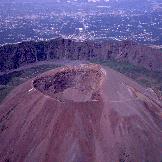
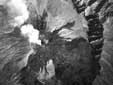
| Luftaufnahme des Vesuv heute. Monte Somme Caldera hinten. Foto Carlo Tripodi |
Aerial view of Mt. Vesuvius cone heute. Mt. Somma caldera is visible in the background. |
Vista aerea del cono del Vesuvio come si presenta oggi. Sullo sfondo la caldera del Monte Somma. |
|
 |
|
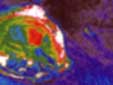
| Thermographie des Vesuv (Temperaturkarte) aufgenommen von Carlo Tripodi im Mai 1997 auf einem Kalibrationsflug. Reguläre Beobachtungen sollten demnächst in Zusammenarbeit mit dem Osservatorio Vesuviano beginnen
|
Thermographic view of Vesuvius (thermal gradients) done by Carlo Tripodi in May 1997 in a calibation flight; a regular surveillance should soon start in collaboration with Osservatorio Vesuviano.
|
Termografia del Vesuvio (gradienti termici) eseguita da Carlo Tripodi nel maggio 1997 in un volo di calibrazione in vista di un programma di monitoraggio in collaborazione con l'Osservatorio Vesuviano.
|
 |
|
|
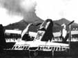
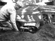
| Im September 1943 bauten die Amerikaner einen Flugplatz in den Feldern von Terzigno ("Pompeii Airfield"). Von hier aus operierten die B-25 Mitchells der 340th Bomb Group in der Cassino Zone. Die Wahl des Standortes bewährte sich allerdings nicht: Die Eruption des Vesuv (18 März 1944, linkes Bild) zerstörte zahlreiche Bomber, die unter mehr als 85 cm Lapilli begraben wurden. Andere wurden durch die Besatzungen dadurch gerettet, dass man in aller Eile davonflug. Die ersten Teile der Flugzeuge, die Feuer fingen, waren die Steuerflächen (Ruder etc.), da sie mit Stoff bespannt waren. Unter dem Gewicht der Lapilli wurden die Hecks hinuntergedrückt. Ein Pilot nützt eine Pause im Aschefall, um von Hand ein Maschinengewehr auszugraben. Die Fotos stammen aus den Archiven der USAF, und wurden verdankenswerterweise vom National Air and Space Museum, Smithsonian Institution, zur Verfügung gestellt.
|
In September 1943 Americans built an airport in the fields of Terzigno, named "Pompeii Airfield", from which the B-25 Mitchells of the 340th Bomb Group operating in the Cassino zone took off. However the location proved inconvenient: the eruption of the Vesuvius (18 March 1944, left image) destroyed many bombers, covering them with more than 85 cm of lapilli. Many were saved by their crews by immediately flying away, but as many remained there on the ground, while their crews looked at them being covered in ash and lapilli. The first parts of the planes to catch fire were the surfaces of aerodynamic control (ailerons, rudders, ...), as they were covered with cloth. Under the weight many bombers laid down on the tail, very soon entirely covered by the lapilli. In a pause of the pyroclastics fall, an airman reaches, digging with the hands, the tail machine-gun of a bomber. It will then be taken apart for the review, operation already carried out in the aircraft photographed in its entirety. The photos are from the archives of the USAF, courtesy of the National Air and Space Museum, Smithsonian Institution.
|
Nel Settembre del 1943 gli americani costruirono in poche settimane un aeroporto nelle campagne di Terzigno, denominato "Pompeii Airfield". Dalla striscia in terra battuta con grelle in ferro, lunga circa 2000 metri, decollavano i B-25 Mitchell del 340th Bomb Group che operavano nella zona di Cassino. La scelta della località si rivelograve; infelice : il Vesuvio in eruzione (18 marzo del 1944) con i suoi lapilli - ne caddero per uno spessore di ben 85 cm - fece strage di bombardieri. Molti equipaggi riuscirono a decollare per portare in salvo i velivoli ma altrettanti rimasero a terra assistendo al progressivo "seppellimento". Da notare come tutte le superfici di controllo aerodinamico ricoperti in tela, furono i primi ad esere bruciati. Sotto il peso molto bombardieri si adagiarono sulla coda, ben presto interamente ricoperta dai lapilli. In una pausa di caduta piroclastica, un aviere raggiunge, scavando con le mani, la mitragliatrice di coda di un bombardiere. Le foto provengono dagli archivi dell'USAF, per cortesia del National Air and Space Museum, Smithsonian Institution.
|
|
 |
|
| Dieses spektakuläre vertikale Luftbild des Vesuv wurde von einem britisches Aufklärungsflugzeug im Jahr 1943 aufgenommen. Der Grosse dunkle Fleck rechts ist die Lava von 1929. Sie befindet sich im «Valle dell'Inferno» und erreicht den Calderarand (Mt. Somma). Die andere dunkle Lava mit der zickzackförmigen Strasse (heute: Matrone-Strasse) stammt von der Eruption 1906. Norden ist rechts. Unbekannte Herkunft, möglicherweise «Trustees of Imperial War Museum». |
This spectacular vertical aerial photo of Vesuvius was taken from a British reconnaissance aircraft in 1943. The great black spot on the right, that lies down in the «Valle dell'Inferno» reaching the margin of the caldera of Mt. Somma, is constituted from 1929 lava. The other dark lava with the zigzaging road (now Matrone road) is from 1906. North is on the right. Unknown source, perhaps «Trustees of Imperial War Museum».
|
Bellissima questa foto zenitale del Vesuvio ripresa da un ricognitore inglese nel 1943. La grande macchia nera sulla destra, che si adagia nella Valle dell'Inferno raggiungendo il margine della caldera del Somma, è costituita dalle lave del 1929. Quella che invece investe la strada a zig-zag (attuale strada Matrone) è la lava del 1906. Il Nord è nello spigolo destro. Fonte sconosciuta, forse «Trustees of Imperial War Museum».
|