Unusual eruptions
16. October 1993
| On October 16th, at 01:10 GMT two strong explosions were felt on the island. Many inhabitants of Stromboli village were woken up by the noise. J. and P. Alean were, at that time, on the island. The next morning we noticed that ash had fallen in Piscità. | Black line: Tremor intensity, yellow: number of events, red: number of saturating events per day. |
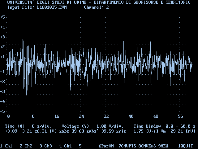
A display of the seismometer recording of the eruption's second minute can be seen here. The recordings of our seismic station show that the tremor decreased after the explosions.
As observed from Punta Labronzo eruptive activity seemed extremely low during daytime of 16. October. On 17. October we climbed to the summit again. The activity level was still unusually low. Only minor ash eruptions occurred at the NE crater. A considerable change was noticed on the near right side of SW crater: Before the eruption a vent had been glowing there at night. After 16. October the opening seemed much bigger than before, but no glowing was observed anymore.
Most impressive were large blocks and spatters reaching two meters in diameter. We found them all over the summit, but also on the path leading up from Stromboli village and on the ridge west of the summit. During none of our previous visits to Stromboli (as far back as the sixties) have we seen so much fresh lava thrown onto the areas which, during the tourist season, are regularly visited by hundreds of people.
![]()
The most distant ejecta were observed at a horizontal distance of approximately 600 metres from crater 3. Reddish ashes and dust fell on the NW slope of the volcano along the Sciara del Fuoco. Some bushes caught fire along the slopes. One lady was injured while asleep near the summit. On 17. October we found a sleeping bag and foam mattres, both damaged by a cowpat bomb:
![]()
The map below shows the approximate distribution of fresh ejecta as observed by us. We only mapped the ejecta visible from the normal route to the summit and when descending via the Porta delle Croci. The base map was scanned from sheet Nr. 244 I SE 'Isola di Stromboli' of the series M 891 by the Istituto Geografico Militare, which is based on aerial photographs from 1937; scale 1:25'000:
![]()