Guadeloupe and Martinique
Montagne Pelée and Saint Pierre - The 1902 Eruption and Geological Background |
|||
| After fumaroles had reactivated on the summit since 1889, the first magmatic activity started on 24 April 1902 with phreatic eruptions. A rapid escalation reached its climax at M. Pelèe on 8 May 1902 when a laterally directed surge produced huge pyroclastic flows that buried 58 square km of land, destroying the south-western flank of the volcano, including the town of Saint Pierre and causing about 28'000 deaths.
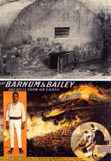
Pyroclastic flow ("nuée ardente") descenting from Montagne Pelée towards St. Pierre. Only a few dozen people survived, although the legend spread about a single survivor, Louis-Auguste Cyparis, nickname "Samson", who was at the time in jail. How little was known about the deadly "nuées ardentes" (pyroclastic flows), at the time, is illustrated by the fact that other villages around the volcano were not evacuated after the initial tragedy of St. Pierre. Therefore, on 30 August 1902 other pyroclastic flows killed another thousand people in Morne Rouge. |
|||
| This rare photo shows St. Pierre after the first pyroclastic flow of 8 May. All houses had robust concrete walls, but only those aligned in the direction of the flow (coming from the volcano in the background) remain upright. |
St. Pierre after other many pyroclastic flows, in July 1902. Now even walls aligned parallel to the flows are destroyed and buried. Note shops of Figuier along the shoreline, which were left untouched until today (see the panorama pages). |
Mouillage Cathedral in summer 1902 (left), when many pyroclastic flows had destroyed and buried most of it. On the right, its interior at the end of the 19th century shows the weakth of St. Pierre at that time. |
A spectacular spine grew in 1903, at a rate of 15 m/day. Viscous andesitic magma rose from the conduit maintaining its shape even in the air and reaching a height of 350m. Note people on the left and Morne Lacroix below the dome (right). Today this area is lush with tropical vegetation. |
Martinique Island is located in the central part of the Lesser Antilles arc, along which the eruptive activity is relatively low, controlled by the slow rate (about 2 cm/yr) of the subduction of the Atlantic oceanic lithosphere under the Caribbean plate. Martinique volcanic activity starts in the Lower Miocene, migrating with time from the Southeast to the Northwest. The 300'000-year-long volcanic history of Montagne Pelée, the island's only active volcano, is divided into three main periods. The most recent phase - about 14'000 years - is marked by two eruptive styles:
At least 10 major eruptions happened in the last 5'000 years, 4 during the last millennium. A dome-forming eruption happened shortly before European arrival (1635), and is probably responsible for the name of the volcano, "mountain without vegetation". The last two eruptions (1902-1904 and 1929-1932), also formed domes. The one of 1929 was less destructive and produced only block- and ash-flows into the Rivière Blanche valley. Note that both eruptive styles produce andesitic products with identical bulk rock, phenocrysts and glass compositions. Moreover, the transition between them apparently happens during magma ascent from the storage zone to the surface, and is not due to variations within the magma storage region. |
|||